Winter Storm Snowmagedocalypsicane (Tonight-Wednesday Winter Storm) **FINAL FORECAST**
**NOTE: Ice accumulations >.1″ are significant and potentially dangerous
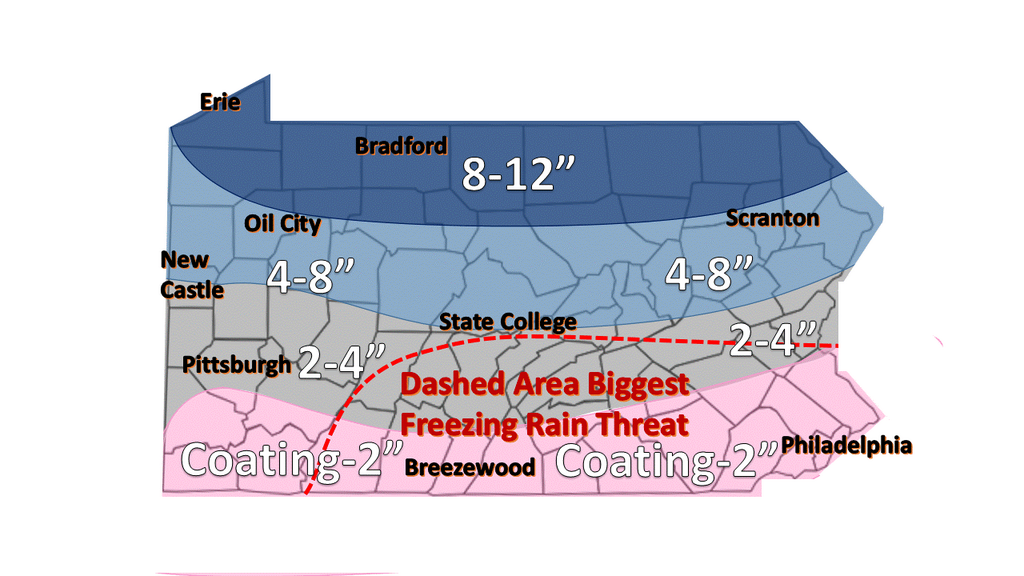
Snow/Ice Forecast:
-
Erie: 8-12″
-
Oil City: 5-10″
-
Franklin: 4-8″
-
Butler: 3-6″
-
New Castle: 3-6″
-
Pittsburgh: 1-3″ dahntahn; 2-4″ in the Burbs. (Up to .2″ of ice)
-
Uniontown: Maybe an inch or 2. Sleet/rain mainly.
-
Bradford: 6-12″
-
State College: 3-6″. (<0.1″ of ice)
-
Breezewood: 1-3″ of snow. (Up to 0.5″ of ice)
-
Scranton: 5-10″
-
Reading: 1-3″ of snow. (Up to 0.3″ of ice)
-
Philly: 1-2″ of snow. (Up to 0.3″ of ice). Burbs north could see 2-4″ of snow (Up to 0.5″ of ice)
-
NYC: 2-4″. (Up to 0.4″ of ice)
-
Frederick, MD: (Up to 0.4 inches of ice)
-
DC: Mainly rain with some crap potentially mixed in. Ice should stay north of city.
-
Start: Outer bands move in by 5pm. Around 6pm steady snow moves into western PA
-
End: Around 6pm Wednesday
-
Biggest threats: Heavy Snow, Freezing Rain/Ice, Low Visibilities, Untreated Roads, Hilly Roads Covered In Ice. Most extreme cases: Power lines down from heavy snow/significant ice.
-
Up to 0.5 inches of ice in southern PA and northern MD.
I joke about the winter storm names, but:
- Drive safe. DO NOT drive if you do not have to
- Stick to main roads and away from big hills. Especially if icy.
- Don’t overexert yourself shoveling snow. (Heavy wet snow = Heart attack snow)
- Be safe and build some extended family members of mine!